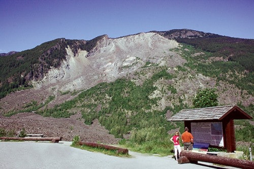
The Hope Slide is one of the most notable landslides in Canadian history. After 48 years, the scarred mountainside and debris field remain a spectacular sight.
In the early morning of Jan. 9, 1965, the collapse of Johnson Peak sent tons of rock, mud and trees crashing down onto the floor of the Nicolum Creek valley, burying three kilometres of highway plus Outram Lake. Four motorists travelling the highway were killed.
When the dust settled, the debris field at some points measured a depth of 80 metres.
The force with which the 47 million cubic metres of rock, soil and snow crashed down into the valley, was so great that debris washed 150 metres up the opposite mountainside before crashing back down into the valley. A telltale treeline differentiation can still be seen today. The tremendous impact is believed to have set off seismographic readings at an earthquake monitoring station in Penticton, which led to the belief that The Hope Slide was triggered by an earthquake.
Today, geologists theorize that the aging Johnson Peak, riddled with factures and weak layers of volcanic rock, simply gave way to gravity.
A viewpoint located 16 kilometres east of Hope on Highway 3 gives travellers a spectacular view of the damage and acts as a permanent reminder of the power of Mother Nature.