Over thirty years ago, the province undertook an ambitious project of constructing a new highway route into the interior of British Columbia. The first phase of the project, between Hope and Merritt was built so that it could be opened in conjunction with the 1986 World Exposition in Vancouver that focussed on a theme of transportation and communication - Expo ’86. The new highway was built on an accelerated schedule that was unprecedented in British Columbia history and the resulting roadway was hailed as a modern engineering triumph when it opened.
That highway became known as the Coquihalla Highway, or as it is commonly referred to, “The Coke”. It was opened with great fanfare 25 years ago this week on May 16, 1986. The frenzied years of construction that preceded that day, coupled with the opening of this alternative travel route, changed our community of Hope and the surrounding region forever. This is therefore an important time to reflect back on a momentous ground shifting event.
The decision to build the highway route was many years in the making with the Merritt Board of Trade leading the lobbying efforts with successive B.C. governments over many decades. One of their most well known schemes to draw attention to the potential of this route was a vehicle caravan that was staged eight times starting in 1963, over the abandoned Kettle Valley Railway grade between Merritt and Hope. Government spokespeople on both ends of the political spectrum both promised to build the route and then stated it would never be built.
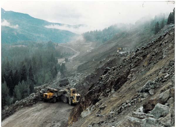
In 1973, the B.C. Department of Highways initiated a reconnaissance survey through the Coquihalla Pass deciding to pursue a route through the Boston Bar Creek Valley, despite its 67 known avalanche paths.
It was not until January 1979, however, that the first construction contract was finally awarded to start work on the route. That first contract C3760 was valued at $4,279,330 to build 4.5 km of four-lane highway from south of the Coquihalla River at Nicolum Creek to the confluence with Peers Creek, just outside of Hope. The successful contractor that was awarded the work was none other than Emil Anderson Construction Ltd (EAC) based in Hope.
While work was finally underway on the route, it did not progress very quickly. It was not until 1984 when Premier Bill Bennett announced that the project would be “fast tracked” so that it could be completed to coincide with Expo ’86, that things really began to hum in and around Hope. Workers flooded into the area and filled all available accommodation to capacity; all local businesses were busy, busy, busy!
Over those few years EAC went on to complete five of the 24 grading contracts on the project, building 24.2 km of the route by adding the following jobs to their work schedule: Peers Creek to Ten Mile; Larson Hill to Crossing No.6; Crossing No. 3 to Larson Hill and Dry Gulch to the Summit.
The 115 km roadbed between Hope and Merritt followed the route of the early Hope-Nicola Valley cattle trail (1876), the Kettle Valley Railway (1913-59) and oil and gas industry pipelines (begun in 1958) through the Cascade Mountains, following the Coquihalla and Coldwater Rivers as well as Boston Bar Creek.
Construction work included 13 interchanges, 38 bridges and overpass structures, 19 vehicle underpasses, 28 protection devices, a 300 metre snow shed and many other avalanche control installations, as well as 18 river diversions and 50 pipeline crossings plus new highway park facilities. It involved the production and placement of 125,000 tonnes of concrete, 3,735,000 tonnes of gravel, 900,000 tonnes of asphalt, 20,000 tonnes of steel and 160 kilometres of median and guardrail as well as the moving of astronomical quantities of dirt and rock.
The construction phase mobilized literally armies of men and equipment creating 10,600 jobs.
Among the many features that were unique to the route when it opened, was a wildlife control program of fences, gates, underpasses and even an overpass, to keep migrating deer, moose and other wildlife away from traffic.
Construction work in the Hope area included three underpass structures, three bridges and a bypass route that shifted traffic away from the roadways now known to us as “Old Hope Princeton Way” and “Flood Hope Road”. Access that had existed along level crossings all along the roadway was now reduced to five new interchanges.
The Highway #1 route between Hope and Bridal Falls was also upgraded. Traffic would move faster from Hope in both eastbound and westbound directions along a total of 21 km of new freeway lanes, and the economic impact of those improvements would change the face of Hope forever.
On May 16th, 1986 Hope was decked out in new vinyl street banners promoting the Coquihalla Highway name and logo. A stage in Memorial Park featured speeches by Premier Bill Bennett; Minister of Transportation & Highways, Alex Fraser; MLA for Yale-Lillooet, Tom Waterland; and Mayor of Hope, Bud Gardner. A pancake breakfast was served under huge tents and then a convoy of busses carrying dignitaries and invited guests left for Merritt. The Premier led the convoy in an open air convertible that smashed through paper banners strung across the new highway lanes. They stopped at the Coquihalla summit to dedicate a time capsule and then moved on to Merritt for further celebrations and a rodeo.
A whole new reality had dawned upon Hope, the Fraser Canyon, the Hope-Princeton corridor and the communities throughout the Merritt and Nicola Valley region.
The opening of the highway in 1986 was not without controversy however, and a public report by inquiry commissioner Douglas MacKay, lawyer George Macintosh and forensic accountant David Hooper released in 1987, found that the highway had cost much more than the budgeted $250 million.
The Coquihalla between Hope and Merritt also became the only highway in BC that charged motorists a toll. The toll plaza at the summit was designed to accommodate 13 toll booths for 14 lanes of traffic making it the widest section of highway grade in all of the province.
Tolls were collected up until Friday, September 26, 2008. At that point the province had collected a total of $845 million in tolls over the 22 years since the highway had opened. Since the route had originally cost $848 million to build in three phases, Premier Gordon Campbell announced that the route had been paid for and the toll plaza would close immediately.
The Phase 2 section of the Coquihalla Highway, the 80 km stretch between Merritt and Kamloops, with 8 bridges and 6 underpasses, opened in Sept 1987, and the Phase 3, Coquihalla Connector section, a 108 km stretch from Merritt to Kelowna opened in Oct 1990.
To learn more about the building of the Coquihalla Highway and its grand opening plan to visit the Hope Museum at 919 Water Avenue this summer. The Museum opens for the season on Saturday, May 21 and will be open until the Labour Day weekend in September from 10 a.m. to 4 p.m. daily. Admission is by donation. On your way in to the Museum take a moment to read the plaque on the large boulder along the front entrance walk. It was unveiled during the highway opening ceremony 25 years ago and states “Coquihalla.... A Great Point of View”.
This article was researched and written by Inge Wilson of Destination Hope & Beyond Services, operating The Hope Museum on behalf of the District of Hope, with the valued assistance of Fred Robinson, Fred Fandrich, Emil Anderson Construction Ltd, Gwen Miller, Steve Wilson and Jack Delair who have contributed memorabilia, photographs, maps and information about the Coquihalla Highway. Anyone that wishes to contribute further stories and items about this important historic event should call the Hope Museum at 604-869-7322 or stop in at 919 Water Avenue.