Kimberly Campbell and Inge Wilson
Contributors
The Hope Visitor Centre & Museum Complex usually provides a stopping point for travellers seeking information about attractions, activities and accommodation throughout our area. But this past week, visitors have also been asking about the swollen Fraser River and what flood risk it might pose to our community and the Fraser Valley.
In light of these questions about high water levels on the Fraser, museum staff have done some research to uncover what sort of impact the Fraser River floods have had on our community throughout recorded history.
The first flood on record that affected the Hope area occurred in May and June of 1894. On May 29 it was reported that several bridges north of Yale had been washed out by the high water and throughout the following weeks nearly every bridge on the old Cariboo Wagon Road would succumb to the water. The Alexandra Suspension Bridge, built in 1864, partially collapsed, but did not wash out. It remained broken, dangling over the canyon until a new steel and concrete bridge was constructed there for the highway in 1926.
Closer to Hope, those living at Katz Landing and Union Bar vacated their homes and headed for higher ground until the water receded. The Fraser peaked at Hope on June 9, 1894 with an estimated discharge of 16,990 cubic metres per second.
Just over 50 years later, in 1948, the Fraser Valley was hit by what has become known as “the most disastrous flood.” While the flood waters did not reach quite the same heights as in 1894, because of the increase in population and development on the floodplain, the damage and impact on communities was greater. While the town of Hope escaped the flood and remained largely “high and dry,” nearby areas including Flood and Laidlaw were not so lucky.
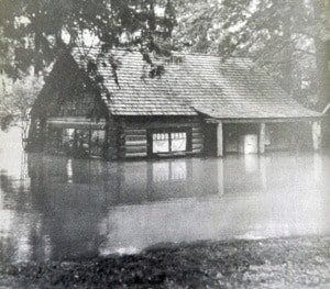
On Croft Island, several cabins belonging to Croft Island Resort had to be anchored to nearby trees to keep them on the property. Fourteen families from Herrling Island were evacuated, and 35 families from Laidlaw were forced to take themselves and their livestock, including cattle, sheep, pigs, and chickens, to higher ground at the Restmore Lodge, just west of Hunter Creek. Cliff Murphy, who had just turned eight years old, recalls his older brothers leaving for work at 6 a.m. and discovering water starting to “trickle through the field and come across the road” so they “went around honking the horn to notify everybody that the river was coming over” and by 8 a.m. the river had come right through and was filling up the Murphy’s back field. When the flood waters receded and the Murphy’s returned home they were greeted with “sand and mud all over the place...and of course mosquitoes like you wouldn’t believe!”
In Laidlaw over 1,000 acres of farmland were submerged but, as Virginia Nash recalls, within the town of Hope “the mouth of the Coquihalla could have been flooded but hardly anybody lived there” so no homes were affected. All in all, the 1948 flood waters reached an all-time recorded high of 10.973 meters with a discharge of 15,200 cubic metres per second on May 31, 1948.
In 1972, the Fraser River again experienced record flood waters – the second highest in recorded times with a discharge of 12,900 cubic metres per second and a maximum height of 10.141 meters at Hope on June 16. Wardle Street and part of Seventh Avenue were submerged, and on Tom Berry Road 10 houses were flooded and families were forced to evacuate their properties. Pumps were brought in to remove water and residents were able to return home after approximately a week.
Despite being surrounded on three sides by water, Hope has repeatedly escaped the massive battering that Fraser River floods have wrought on the rest of the Fraser Valley.