A new recreation and trail map has just been released for Manning and Skagit Valley parks.
The first of its kind in more than 20 years, Clark Geomatics Corp. has created the only dedicated hiking, biking, horse riding and cross-country/backcountry ski map for the parks, which share boundaries and span a large geographical area.
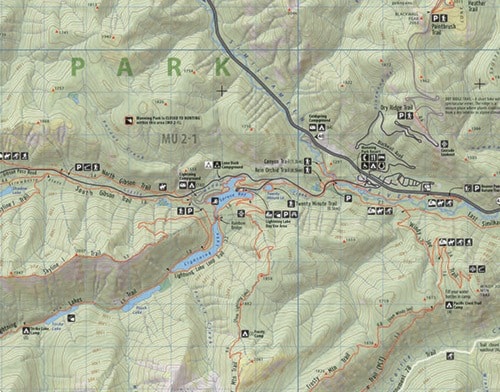
“We created a map that’s going to essentially fit people’s needs at the recreational level,” said Jeff Clark, lead cartographer at Clark Geomatics Corp. “The Manning/Skagit Valley map is unique in that it is the only recently published map for the area that includes both provincial parks. The map promotes local historical trails and great effort was taken to ensure their accuracy using GPS technology.”
The background image of the map is based on up-to-date satellite imagery that is used to produce a picture showing forested areas, alpine meadows, bare rock and ice features (glaciers and ice fields). Satellite technology helped Clark get accurate information on the ground, for example logged areas and tree-lines. Trails, hikes, routes and traverses are derived from GPS sources and overlaid onto the topography.
The map features 1:50,000 scale, shaded relief, detailed 25m contours, GPS-Ready: UTM and Lat/Long, hike and trail guide with descriptions, winter/summer trails and routes, trail and route distances, regional climate charts, historic hiking/horse riding trails, historical place notes, motorized and non-motorized areas, hunting and non-hunting areas, campsites/campgrounds, and local services.
Clark partnered with BC Parks, The Friends of Manning Park, and the Hope Mountain Centre to ensure the accuracy of the GPS’d trails, information guide and park features.
“There was an urgent need for a new map with the kind of detail that this map includes,” said Kelly Pearce, program director with the Hope Mountain Centre and former Manning Park naturalist. “These are heavily-used mountain parks and they really deserve a good map to go with them for public safety and enjoyment. For map users, it’s nice having that relief shading because it really makes the physical terrain pop up.”
The recreational and backcountry map can be purchased online from Clark Geomatics at http://www.clarkgeomatics.ca/map-products.html or at the Hope Visitor Centre & Museum Complex, located at 919 Water Ave.