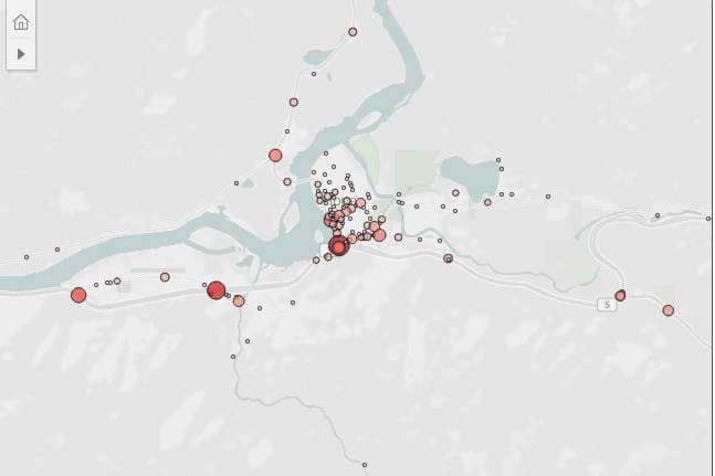
Year after year, the worst intersection for crashes in Hope is the main entrance and exit to town.
ICBC has released its most recent five years of data for intersection crashes across B.C. communities. The Old Hope Princeton and Trans Canada Highway intersection has seen 49 crashes between 2016 and 2020, at a rate of about 10 crashes a year.
The Flood Hope Road off-ramp coming east had 35, and the Flood Hope on-ramp/off-ramp area had 22 crashes in the same time frame.
Highway 5 and Othello has had 18 crashes in the five years, and Wallace Street and Water Avenue saw 17.
By comparison, Chilliwack’s most dangerous intersection is Luckakuck Way and Vedder Road, with 71 crashes over the five years.
Agassiz’s Evergreen Drive and Lougheed Highway saw seven crashes in five years, while Vancouver’s top crash spot is the Knight Street Bridge, with 178 crashes over five years.
ICBC notes on their website that the data is not exact, as crashes that are midway between intersections are mapped on the nearest intersection. The map also does not include accidents that involved parked cars, or those where nobody is injured, or in parking lots.
READ MORE: Kelowna high school students killed in single-vehicle crash
@CHWKcommunity
jessica.peters@hopestandard.com
Like us on Facebook and follow us on Twitter.
Want to support local journalism during the pandemic? Make a donation here.