There are many places in the Hope and Canyon region where you can take a hike — but walking on a path that is dripping in historical significance is a special experience that can leave you both physically and mentally... and maybe even spiritually invigorated.
The old Alexandra Bridge, a five minute drive north of Spuzzum, is one of the Fraser Canyon’s historic jewels and it’s easily accessible on a gently inclined walk that takes about 10 to 15 minutes each way.
Your first glimpse of the old bridge will be when you cross on the ‘new’ (1964) span and look upstream a few kilometres to the old suspension bridge that carried vehicles from 1926 until the new span opened.
Look for the parking lot on the river side of the road and turn in when safe to do so. At the north end of the parking lot, you’ll see the old road sloping into the forest, or pick up the road by taking a trail down from the pit toilets. Cross the railway tracks with care and continue on to the bridge.
I recall traveling in the canyon with my parents and siblings in 1962, on our way to Barkerville to visit my Uncle Jack, who was working a placer gold claim there. We crossed the old bridge and I remember many delays on the road, due to the massive construction that was converting the treacherous 1920s Cariboo Highway into the modern highway we enjoy today.
A full 100 years before that, the first suspension bridge (torn down in 1912) was being constructed at the narrowing in the gorge, under the direction of Joseph Trutch, the commissioner of public works for the colony of British Columbia. This would be a key link in the Cariboo Wagon Road, from Yale to Barkerville.
Trutch named the span after Princess Alexandra of Wales, the great grandmother of Queen Elizabeth.
This was some 20 years before the CPR brought the railway through the canyon, linking British Columbia with the rest of Canada. These were infancy days of our province but these were old lands for the local Nlaka’pamux First Nation, which had villages on both sides of the river. Lands on the west end of the bridge are now reserved for First Nations use.
The provincial government established the Alexandra Bridge Provincial Park in 1984 and it is a popular rest stop and day use area in the non-winter months — but Kelly Pearce and other outdoors-oriented people would like to see improvements at the site.
Pearce is a long-time historian and naturalist in the Hope area and is the program director for the non-profit Hope Mountain Centre for Outdoor Learning (HMCOL). HMCOL is working closely with Spuzzum First Nation and the New Pathways to Gold Society to improve the Alexandra Bridge and park.
“The New Pathways to Gold Society has a mandate to build or improve heritage tourism experiences along the gold trail to Barkerville,” says Pearce. “They have committed $80,000 to restore the picnic area so that more people stop there. A future phase will see the improvement of interpretive signage, which has fallen into disrepair.”
CN Railway has also begun to meet with New Pathways about a level crossing, which would make the route accessible by wheelchair and safer overall.
“Generally, there is a need in the canyon for more rest stops and places to stay,” he adds, “and this parking lot is barricaded in late September and reopened in May. It certainly should be expanded to at least eight months — and preferably year-round.
“This is one of the few places where you can safely access the Fraser River in the canyon,” says Pearce.
“It’s awe-inspiring to see the force of the water in spring run-off.”
When you reach the entrance to the bridge, take a look over the edge at the foundations under the concrete towers. That is 1861 stone work — so tight and well done that the 1926 concrete was poured onto the old foundations.
The new deck was constructed much higher than the original Trutch bridge, as the 1894 flood taught engineers a lesson.
“That was a one-in-200-year flood, and it significantly damaged the wooden deck,” says Pearce. “By that time, the CPR had built the railway, so the wagon road became redundant.
“By the 1920s, motorists were clamouring for places to drive, so there was a big push for governments to open up roads,” explains Pearce. Once again, a bridge crossing at Alexandra was vital.
There was a cost though: tolls started at $1, according to historian Michael Kluckner.
The second span served the province for nearly 40 years, though one look at the narrow deck and its approaches will tell you how much of a bottleneck the bridge would cause in modern times.
A new solution was needed — and the ‘new’ span downstream has already given more years of service to motorists than its predecessor.
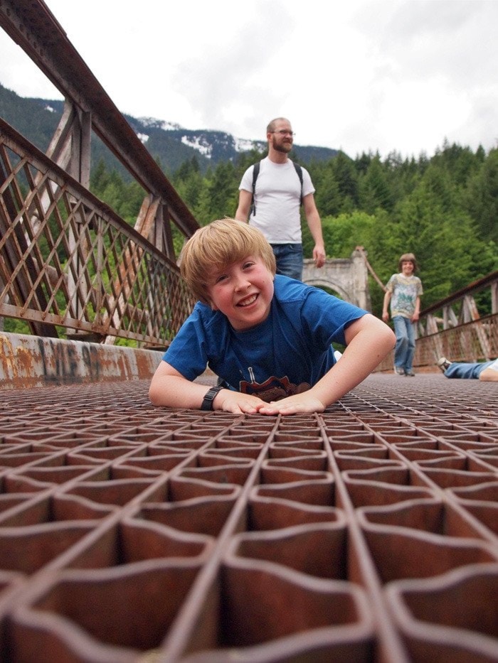
A few notes before you step out on the deck of the old bridge: it’s safe for cyclists and pedestrians — but don’t look down if you’re afraid of heights, or have vertigo.
This is a see-through deck, made of metal mesh, and it’s one of the bridge’s big attractions. Imagine the whining sound that tires made when vehicles crossed the bridge.
Many people are passionate about the importance of saving the old Alexandra span, which is the responsibility of the Ministry of Transportation and Infrastructure. Rusting cables and alkali silica reactivity in the concrete are concerns that need to be addressed.
“The bridge played such a key role in B.C.’s early history. We can’t afford to lose this gem,” Pearce says.
Next week, join us for an equally historic hike: the definitely not wheelchair-accessible Tikwalus Trail.