Feeling guilty about eating that bacon cheeseburger and fries? The Mount Hope Lookout Trail can help.
Hope’s version of North Vancouver’s famous Grouse Grind has much to offer — and calorie burning is a benefit that becomes obvious within the first few minutes on the trail. Over the two kilometre route, which was developed in the late 1980s, you’ll be averaging a one-metre rise for every four metres of distance. The Grouse Grind is 2.9 kilometres one way and has an average one-metre rise for every 3.6 metres of distance.
Advantages for the Lookout Trail? It’s right here, it’s free — and you get to hike back down, for a total four-kilometre round trip. On the Grind, it’s one way only, with a paid tram ride to get back to your car.
“The Grind is another third longer and is more intense,” says local fitness instructor Kim Richardson, who has climbed both routes and makes good use of the Lookout Trail.
“Hill climbing builds excellent aerobic endurance, especially on the way up,” she says.
“Coming down can be stressful on the knees — but I now use climbing poles. They give you a good upper body workout and they make it safer, coming down.
“It’s a bit like comparing a two-wheel drive vehicle to a four-wheel drive,” says Richardson.
“With all the benches they have installed along the way, the trail does afford chances for different fitness levels,” adds Richardson. “And the trail is really well-maintained.”
For people who are just starting to build up their fitness — or those who don’t have time for the whole climb — Richardson suggests only travelling part way up, to the Joan Greenwood loop trail in the first third, for example.
If you have a few more steps left in you, you can continue to the first lookout, about five more minutes up the trail.
If you’re in reasonable shape and you want a conditioning boost, Richardson suggests using the hill for interval training. “Go all-out for 30-second bursts,” she says. “This moves you into your anaerobic zone.”
Inge Wilson, manager of the Hope Visitor Centre and Museum Complex says the trail is used extensively by people in the community that are training for something, or are trying to set a personal best.
It’s also easy to give directions to interested tourists, as staff can point to the rocky slope of the lookout from the front door of the visitor centre. Parking is near the old train station, south of the highway overpass. Look for signage at the parking lot.
“I find coming down is mentally and physically tougher than going up,” cautions Wilson, who goes on many hikes with the Hope Outdoors Club. “You have to pay a lot more attention on your footing, to avoid taking a tumble — and anyone who has issues with knees or hips will feel it... even if they are taking rests.”
The “Hope Hustle” trail race is held each September. It starts at the trailhead and goes to the main lookout. The fittest — and lightest — athletes have been doing the race in the low 20-minute range. Even under 30 minutes requires a high heart rate and lungs on fire.
Try that pace, if you’re up to it — but the info centre staff recommend a 2.5 hour round trip for the “average” hiker.
Other than the first lookout, most of the hike is in the shade of huge trees, making it much more bearable on a hot day. Along the way, enjoy the bird songs, the earthy smell of the forest and the lush green undergrowth.
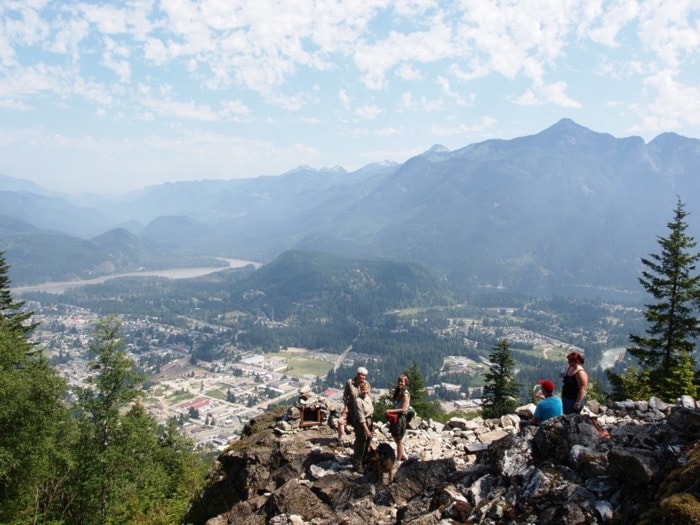
Your ultimate reward is the lookout, 500 metres above the parking lot. On a clear day, you’ll be able to see northward past Yale and all of Hope, including Kawkawa Lake.
If you’re a first-timer, you might wonder if you’re ever going to get there.
Using a pedometer, it took about 3,600 steps to go from the parking lot to the main lookout. Hiking with my friend John Koopman, we took about 42 minutes for the ascent, working at above a 120 bpm heart rate.
The key landmark for us was the long staircase that is filled with rocky rubble. On the right, there is a rocky outcropping. This was at the 32:00 minute mark and 2,900 steps...so about three quarters done.
After the staircase stretch, there will be a long switch back to the right, then a left-right-left and you’ll be at the bottom entrance to the rocky lookout slope. It’s well worth continuing up the trail to the main lookout, which is about 300 grinding steps further.
Unless you’re in a rush, take the time to drink in the view and sign the log book that is stashed in the cairn. Be sociable and have a chat with any hikers that happen to be there. On our trip, we met three women from Agassiz and Chilliwack Lake — and a couple from Wegscheid, Germany: Andreas and Alexandra Obermaier, who took a leisurely 1.5 hours for the ascent.
In the spring of 2012, Katimavik volunteers spent many weeks improving the trail and a group of about 10 local and visiting volunteers put 200 man-hours into transforming the main lookout.
Nat Baker, manager of Pages Book Store, was one of the weekend workers.
“My first impression was ‘this is going to take forever,” he recalled, “but piece by piece, it started to take shape.”
Trail note: Before setting out on the hike, I weighed myself — including my water container. Anything I drank on the trip would be out of the bottle and inside me... at least until it got sweated or breathed out. Weighing myself and the bottle post-hike would show any losses of water.
At the second weigh-in, I tipped the scales at four pounds less. That’s almost two kilograms, which would mean that over two litres of water went “up in smoke,” if you consider the half litre I drank en route.
Our word for the day: hydrate!
Next week, we’ll cover a short and easy hike that has a very cool feature at the end... the see-through bridge deck over the Fraser River on the old Alexandra Bridge trail.