The Hope area has always been blessed with natural beauty: the lakes, the rivers and streams, the towering mountains and trees — but for a small group of locals, a nice view just wasn’t enough.
Thanks to trail builders of the past and present, the area now has 22 established trails, with more under development. For locals or visitors, a large inventory of outdoor adventures begins just steps away from the downtown core. The trails are there for you to take a break from daily life... and maybe even break a sweat.
The Hope Mountain Centre for Outdoor Learning has produced an excellent brochure that outlines key details of the hikes — and The Hope Standard will be focusing on four of the more popular routes over the next four weeks, digging up facts about the history of the trails, what makes them so popular and how you can get the most out of your hike.
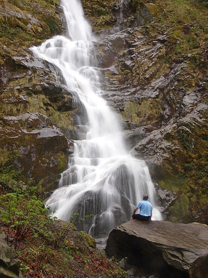
This week, we’ll start with the Flood Falls, which has been a popular attraction for years. The trail has been redeveloped over time and it’s a gently-sloped walk, suitable for the whole family. Within 10 to 15 minutes from the trailhead, you’ll be at the foot of the multistage falls that start some 1,000 metres up the mountain.
The falls are located about seven kilometres west of downtown Hope, south of the Flood Husky truck stop. On Highway 1, take exit 165 and head for the frontage road that parallels the eastbound lane. From Flood-Hope Road, use the exit 165 overpass. Look for a land bridge that crosses the little gully, and the wooden sign that marks the trailhead.
Viewed from Highway 1 on an extremely wet day, you can see at least eight falls streaming down the mountainside — but the Flood Falls are the most prominent and longest lasting into the driest part of the summer.
Inge Wilson, manager of the Hope Visitor Info Centre and Museum says, “The falls are really reliant on heavy rain or snow melt. They are best in spring or fall, when we get those heavy rains. Usually when I go out there, I encounter at least one group, hiking. It’s popular for mountain bikers too.”
Wilson says the Flood name has nothing to do with high water. The Flood family had a farm in the area in the early 1900s and “Flood” was a whistle-stop on the railway, as the farm’s milk was sent by train to points west.
The newest version of the trail was one of the last projects of a seven-year work experience program that saw the development of many new trails in the area, from 1985 to 1992. Working with the Hope Economic Development Committee, Hope Secondary science teacher Rick Piechotta and school board trustee Arlene Webster spearheaded a subcommittee that was tasked with making Hope a destination for outdoor adventures.
Piechotta, who has since retired and moved to Quesnel, says, “The Flood Falls trail came a little later. Don Olds owned some property there before the highway came through and he told me it was beautiful in there.
“The whole idea was to meander through the forest and make it on a wheelchair grade, with a separate loop trail back.”
Unfortunately, funding dried up before the crews could install crushed gravel or recycled pavement, leaving the trail inaccessible by wheelchair — though it is still an easy grade for hikers.
In the 1970s and early 1980s, Flood residents Eldon and Hazel Schmidt operated the Flood Falls Campground, with campsites within five minutes of the falls. If you track eastward from the main trail (or wander to the right on your way back), you’ll find a large grassy field, the site of the old campground. Look carefully and you may find some of the old standpipes that provided water to the campsites.
The idyllic camping experience came to an end when the new Highway 1 cut a swath through the rural neighbourhood, in preparation for Vancouver’s Expo 86.
“There’s a trail that goes from our old campsite to the falls,” says Hazel. “When we moved here in 1971, we were told that it follows the original logging road, where they used horses to get the logs out, in the early 1900s.”
On a hot day in the summer, the falls provide a refreshing splash in a shallow pool. If you want to be in full sun, plan to be there by early afternoon, as the sun is blocked by mountains well before sunset.
In April, you’ll see trilliums growing amongst the ground cover — and during spring snow melt, or on a rainy winter day, the falls will be at their peak flow, with enough “white noise” to block out all sounds from the railway or highway that are less than one kilometre away.
Flood Falls: an easy walk that refreshes the senses.
Next week, we’ll be looking at the popular Hope Lookout Trail, Hope’s version of the “Grouse Grind.”